Dallol is a volcanic explosion crater (or maar) in the Danakil Depression, northeast of the Erta Ale Range in Ethiopia. It has been formed by the intrusion of basaltic magma in Miocene salt deposits and subsequent hydrothermal activity. Phreatic eruptions took place here in 1926, forming Dallol Volcano, numerous other eruption craters dot the salt flats nearby. These craters are the lowest known subaerial volcanic vents in the world, at over 45 m (150 ft) below sea level.
Numerous
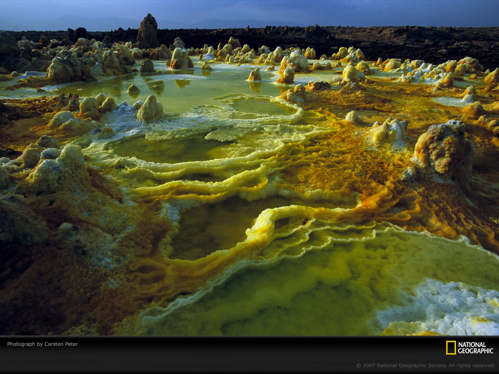
hot springs
are discharging
brine
and acidic liquid here. Widespread are small, temporary
geysers
which are forming cones of salt.
Acidic lakes of the Dallol
|
|
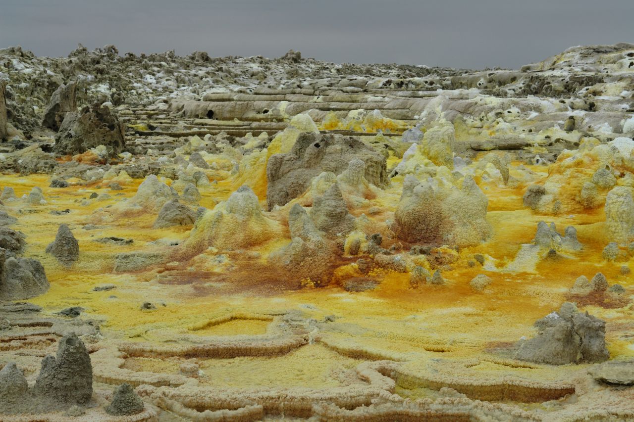
Sulfur, salt, and other minerals color the crater of the Dallol volcano
One of the most unusual places on Earth is
Dallol Volcano. It is dubbed to be the most colourful place on Earth and the hottest place in the world. This is the only volcano in the world below the sea level and without
water over it. This place has got the only geysers of salt and acid in the world - and lots of them!
These unique phenomena have been created by a rare coincidence of several geological factors
Giant lens of salt
Nowadays Danakil Depression is dry desert - but in the past, in Miocene epoch it has been repeatedly inundated by the sea, forming a deep gulf. Every time when this gulf was cut off from the ocean, it dried out, leaving salt deposits.
As a result here has formed more than one kilometre thick layer of salt. Countless caravans have been coming here and mining the salt for centuries - and they still do it today.
Vapour, explosions and maars
Dallol Volcano is not a true volcano. Here, in the thick salt layers has intruded basaltic magma. As the groundwater descends deeper, it meets overheated rocks and turns into vapour. When the pressure of vapour reaches critical level, the ground (here - salt) above this superheated vapour is blown off in spectacular explosion, leaving a crater -maar.
Last time such explosion took place in 1926, some 1.5 km to the south-west from the main crater of Dallol Volcano. Now in the site of this explosion is located deep, 30 m wide, round pit, filled with orange brine.
Will there be more explosions in future? Most likely - yes. This can happen every second.
The 1.5 by 3 km large crater of Dallol Volcano has formed by the collapse of salt layers. Multiple hot springs above the hot magma have washed out the salt layers, leaving voids, which at some moment have collapsed.
Most colourful place on Earth?
The salts of Danakil Depression are white or transparent - just like the table salt. Here have been mixed diverse salts - the well known halite (NaCl), but also sylvite, carnallite, kainite.
Volcanic heat though brings up from the depths other, more colourful elements - the bright yellow sulphur and the iron. Iron adds lots of colors - green, blue-green, orange, brown.
All of this - the immense layer of salts and the colourful iron compounds and sulphur are blended by the countless hot springs in the crater of Dallol Volcano. This has resulted in one of the most unusual landscapes on Earth.
Crater is filled with small ponds of water (no, not water - a brine and often - sulphuric acid with pH below 1!) in different colors. In one pond the liquid might be in poisonous green color, but right next to it there might be a yellow or blue-green pool.
Ponds are divided by salt - and often this salt is white as snow, but also - green, orange, yellow.
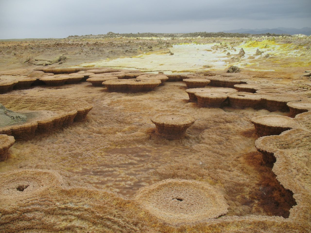
Here have formed also rimstone formations - small stone dams. Again - this is unique place where can be seen rimstone formations made of salt, may be the only ones in the world. Elsewhere in the world rimstones are formed from travertine or sinter - and even such travertine rimstones are quite rare.
sources: www.google.com
www.wondermondo.com
national geographic